| GEOGRAPHY AND CLIMATE | Sevastopol.org |
The geographical center of the city is at 44'37" latitude and 33'31" of longitude. The distance from Sevastopol to Kiev - 1,050 km; to Moscow - 1,500 km; to Yalta - 85 km; to Istanbul - 490 km; to Rome - 1,700 km; to Marseilles - 2,100 km; to Paris - 2,400 km; and to London - 2,800 km. The city area is 864 square kilometers, which is equal to the territory of Moscow, New York City or Shanghai. Taking inot account the water area of internal sea bays (216 kms2), it exceeds 1,000 km2. The length of the coastal city boundaries is 158 km, the overland border - 106 km. The location of the central part of city, with its mountainous relief, broken by deep ravines and beams, with plenty of deep sea-water bays, is a good naturally protected navigable waterway and transport approach. In other parts of the city territory the mountaineous terrain prevails, with some fertile valleys and occasional flat areas.
The climate of the Sevastopol region is close to the subtropical climate of the Southern coast of Crimea (dry, clean air, non-freezing sea). In winter the temperature fluctuates between -2 and + 7 degrees Centigrade. The summer heat is softened by sea breezes - in the daytime they blow from the sea to the land, at night - from the land to the sea. In the evening it is usually a complete lull for 2-3 hours. The annual amount of precipitation is 500-700 mm.
Time zone: +3 GMT (Moskow time)
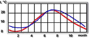 |
_____ temperature of air _____ temperature of sea water |